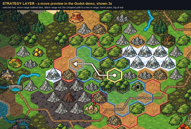
A 32px pixel-art hex strategy map, ready for Godot 4 and Tiled. 479 native tiles on pointy-top 32x32 hexes: ground in 8 materials; shores, rivers, roads and range outlines for every combination of the six sides; 40 map features that stand on the hex; and a strategy layer with hover, selection, path arrows and fog of war. The Godot 4 demo generates an island, paints it with one call, and previews a move: select a hex, see its move and attack ranges, and hover a hex in range for the cheapest path there.
Show full description...
There is a free sampler below: byte-identical copies of files from the full pack.
Spec
Hex pointy-top, 32x32 cell, 768-pixel mask (2:1 slanted edges) Row pitch 24 px, odd rows shifted right 16 px Godot 4 TileSet tile_shape HEXAGON, tile_layout STACKED, tile_offset_axis HORIZONTAL, tile_size 32x32 Tiled orientation hexagonal, staggeraxis y, staggerindex odd, hexsidelength 16, tiles 32x32 Masks bit k = side k, in the order E, SE, SW, W, NW, NE (Godot's get_surrounding_cells order); tile index = mask Features 32x48, standing on the hex Alpha every pixel fully opaque or fully transparent
What is in it
CountWhat
Ground hexes24deep water, shallow water, sand, grassland, forest floor, steppe, snow, volcanic ash (3 variants each)
Shore overlays63a sand-and-foam strip inside a land hex along every side that meets water, one tile per combination (mask 0 is no shore)
Foam-only shores63the same masks with just the foam line, for sand and snow: snow gets no beach, sand no inset outline
River overlays64every combination of sides, plus a round pond and round spring pools
Road overlays64every combination of sides, plus a round plaza
Range outlines128move (blue) and attack (red): a dark keyline and a bright band along the sides that face out of the range, one tile per combination
Strategy tiles336-frame hover pulse, selection ring, 27 path pieces, fog of war (unexplored and explored), two-tone grid line and dotted grid
Map features40pine forest, broadleaf forest, dead forest, autumn forest, grassy hills, rocky hills, snowy hills, marsh, rocky mountain, mountain range, snow peak, volcano, desert mesa, oasis, boulder field, cave, village, market town, walled city, castle keep, fortress, port, farm, windmill, ruined castle, temple ruins, mine, watchtower, stone bridge, standing stones, military camp, shrine, lighthouse, lumber camp, wizard tower, monastery, graveyard, shipwreck, quarry and gold deposit
479 tiles in total. Nothing has a soft edge, so everything stays sharp at 2x, 3x or 4x with Nearest filtering. The see-through effects are ordered dither: the range tint covers 12.5% of a hex and explored fog 50%; unexplored fog is opaque.
Overlays, not transition tiles
Shores, rivers, roads and ranges are transparent hexes on their own layers, painted over the ground. So there is no transition tile per pair of materials: a road crosses grass, steppe or snow the same way, and a shore forms on whatever land meets the water.
The joins are proven, not eyeballed. The build pastes every pair of tiles that can meet across a side next to each other and compares them, pixel for pixel, with the same network drawn in one piece: 12,288 road joins, 12,288 river joins, 6,144 shore joins (full and foam-only shores, and each beside the other), 3,072 range joins and 294 path joins, zero mismatches. The hex mask itself is proven to tile: a staggered field of masks leaves 71,680 pixels covered exactly once, with no gap and no overlap.
Measured across the channel on the shipped tiles, rivers are 5.8-6.5 px wide and roads are 4.9-5.1 px wide, at all six sides and along the way.
The path pieces (6 starts, 6 arrowheads and 15 through pieces) join side to side the same way, so any path draws as one clean line. The hover pulse has a dark keyline inside its light rim, and the grid is two-tone (a light and a dark pixel on every side), so both show on snow and on deep water. In the demo the ranges and the grid are drawn under the features, so a 48 px piece is never cut by a hex outline.
Map features
The water in the port, lighthouse, oasis, stone bridge and shipwreck uses the same shallow-water palette as the water hexes and rivers.
- On a grass patch (grassland and forest floor): pine forest, broadleaf forest, grassy hills, marsh, cave, castle keep, fortress, farm, windmill, ruined castle, temple ruins, mine, watchtower, military camp, shrine, lumber camp, wizard tower, monastery and graveyard.
- No grass under them (any land): dead forest, autumn forest, rocky hills, snowy hills, rocky mountain, mountain range, snow peak, volcano, desert mesa, boulder field, village, market town, walled city, port, stone bridge, standing stones, lighthouse, quarry and gold deposit.
- The oasis is green by design and suits steppe, sand and grassland; the shipwreck stands in shallow water.
manifest.json lists the ground each piece suits, and the demo's island generator only places a piece there.
Godot 4
A ready-to-run Godot 4 project, tested headless in Godot 4.6.3 on the shipped zip:
- hexfall_tileset.tres: eight atlas sources. Features are 32x48 regions with texture_origin (0, 8) so they stand on the hex. Roads and rivers are also a Match Sides terrain set, so the Terrains tab paints them: Godot's own terrain painter placed 364 road and river cells with zero wrong tiles.
- hex_autotile.gd (class HexAutotile): describe the map as data and it paints every layer, including foam-only shores on sand and snow. Every mask is read through TileMapLayer.get_neighbor_cell(), so there is no offset maths to get wrong:
var mats := {Vector2i(3, 2): "grassland", Vector2i(4, 2): "shallow_water"} var roads := {Vector2i(3, 2): true} HexAutotile.paint($Ground, $Coast, $River, $Road, mats, roads, {})
Roads can also be given as links (a side mask per cell, as a pathfinder lays them), so a junction draws as a T, not as a triangle. paint_range() outlines a move range and an attack range; draw_path() draws a path with its arrowhead.
- hex_astar.gd (class HexAStar): AStar2D where a step costs the cell it enters, so a road hex can cost 0.5 and a forest 2, and the path it returns is the cheapest.
- The demo (main.gd, hex_island.gd): a seeded island generator, hover highlight, click to select, move and attack ranges, the path to any hex in range, fog of war and a grid toggle; R makes a new island. It previews a move; nothing moves.
- template.tscn: a blank map with all eleven layers wired up.
On 8 generated islands (6,528 cells), every shore, river, road and range tile the demo painted matched the mask recomputed from get_surrounding_cells(): zero mismatched masks. 16 long paths (425 path cells) all stepped between true neighbours. 9,813 paths checked against a separate cheapest-path search were never more expensive, and 2,003 hexes in move ranges, hovered through the demo's own input code, each showed the path the range promised. After Godot's import the textures are identical to the PNGs, and project.godot sets pixel-perfect import defaults.
Tiled
engine/tiled/ has a tileset per atlas (the features tileset is 32x48 and Tiled bottom-aligns tall tiles, so they stand on the hex; the hover tile is animated) and sample_island.tmx, the island in the screenshots.
Good to know
- Different materials meet at a hard hex edge, the board-game look, and deep and shallow water have no depth transition.
- Neighbouring hexes of one material are cut so the step across an edge is close to the texture's own pixel step. Most materials measure 0.70-0.87 (1.0 would match the step between pixels inside a hex). Snow measures 1.47, so a faint hex edge shows between snow hexes.
Files
tiles/ground/ 24 ground hexes tiles/coast/ 63 shore overlays, named by mask tiles/shore_foam/ 63 foam-only shores tiles/river/ 64 river overlays tiles/road/ 64 road overlays tiles/range/ 128 range outlines (move and attack) tiles/strategy/ hover frames, selection, path pieces, fog, grid features/ 40 map features, 32x48 atlas/ one atlas per kind previews/ the demo island, and 4x preview sheets of every atlas engine/godot/ Godot 4 project, TileSet, hex_autotile.gd, hex_astar.gd, demo + template engine/tiled/ tilesets + example map manifest.json every tile with its atlas coords, mask and sides
Free sampler
The free sampler has 9 ground hexes (grassland, shallow water, sand), 16 shore overlays and 8 map features: byte-identical copies of files from the full pack.
How the art was made
The terrain textures and the map features were generated with an AI image model and are disclosed as such on this page. Those images are not pixel-exact, so none is shipped as-is: every tile was resampled to a true native grid, keyed, palette-limited and given binary alpha, and the hexes were masked by code. The shores, rivers and roads are geometry filled with the sampled textures; the range outlines and the rest of the strategy layer are drawn by code. PROVENANCE.txt and PROMPTS.md in the zip record exactly how.
Licence
Use in any number of commercial or non-commercial games, modified or not. No credit required. You may not resell or redistribute the assets themselves as an asset pack.
 GetAssetPack